Oklahoma is a beautiful and
diverse state. There are many
interesting and beautiful places, and some of them I’ve never seen! So, when we moved back to Oklahoma, in 2010,
I decided that I would make a concerted effort to visit and see them.
 Oklahoma has 77 counties, and I
have made it a goal to visit every one of them over the next few years. Many, along the I-35 corridor are easy. One trip to watch Susan’s nephew play a high-school
football game in the Tulsa area: check.
Susan, Erin, and I drove the famous Talimena drive, in eastern Oklahoma
and, and saw some beautiful mountains and scenery, and visited a dozen
counties; check, check! A fun weekend
with our friends, the Broussard’s, at Lake Broken Bow, in far southeast
Oklahoma: check, check, double-check! But you can imagine that there are still a
few corners that may be harder to get to without a dedicated effort.
Oklahoma has 77 counties, and I
have made it a goal to visit every one of them over the next few years. Many, along the I-35 corridor are easy. One trip to watch Susan’s nephew play a high-school
football game in the Tulsa area: check.
Susan, Erin, and I drove the famous Talimena drive, in eastern Oklahoma
and, and saw some beautiful mountains and scenery, and visited a dozen
counties; check, check! A fun weekend
with our friends, the Broussard’s, at Lake Broken Bow, in far southeast
Oklahoma: check, check, double-check! But you can imagine that there are still a
few corners that may be harder to get to without a dedicated effort.
As I do consider myself a true
“Oklahoman”, I am a bit embarrassed to admit that I had never been to the
Oklahoma panhandle. The former Cherokee
Strip holds three of Oklahoma’s largest counties, some admirable vistas, and
probably ten times more cattle than people!
Susan had to make a weekend trip out to west Texas to visit her cousins,
after their mother died. This left me
with a long, lonely, weekend to travel, so off we (Loma and I) went to explore!
There are many rustic views in
this part of Oklahoma. West of Alva, the
plains turn into hills, and you pass the broad Cimarron River. Not much water, but a wide swath through the
plains as the river meanders south towards Guthrie, and ultimately into the
Arkansas River near Tulsa. Past Freedom,
I detoured south to the Alabaster Caverns State park. It was only 4 PM, so I took the last tour of
the day into the caverns. It lasted
about 45 minutes, and included the obligatory “total dark” moment, some great
alabaster crystals, and bats on the ceiling.
It was a perfect nature hike for future grandkids. Note to self……

 Well, since Loma got equal
billing in the title of this adventure, she needs to get her story out too. To that end, I’ll include three short Loma
stories to share her highlights of the trip.
So, you’ll find three Loma anecdotes included in this report, including
stories about horses, cows, and a modern day Oklahoma land run!
Well, since Loma got equal
billing in the title of this adventure, she needs to get her story out too. To that end, I’ll include three short Loma
stories to share her highlights of the trip.
So, you’ll find three Loma anecdotes included in this report, including
stories about horses, cows, and a modern day Oklahoma land run!
Loma (horses): I pulled off on a country road to let Loma
out. We both stepped out of the car to
stretch our legs. Loma looked up at the
nearby field and took off to chase two horses that were in the field. Oh-no, I said. I yelled for her to come back, but she kept on
chasing them towards the far end of the field where a house was at. I could just see me having to walk to the
other end, dodging horse droppings, just to have to explain to some shotgun
toting farmer, that my dog doesn’t come when called. She finally heeded my calls (likely after she
got close enough to know that horses are BIG) and ran back to the car leaving
me in the field. I swear she had a grin
on her face.
 The sun had set before I got into Guymon. Wow, that glare was brutal, as I drove due west into the setting sun! I had no problem finding the Super 8 Motel, along the highway. The Super 8 Motel, was only $59, with a hot breakfast, and a $7 pet fee. I found Martha’s Diner, which advertised a Green Chile Chicken Fried Steak. You couldn’t have suggested anything better! It was really good. Later that evening, Loma helped me choose which Book-on-Tape to listen to during the drive. Loma and I fell asleep watching the Lakers lose on ESPN. It was a good day!
I am a notorious early riser (sorry
Loma). By 7 AM, I had showered, eaten a (very
good) hot breakfast, walked Loma, loaded up, and checked out. Today’s agenda includes the rest of the Oklahoma
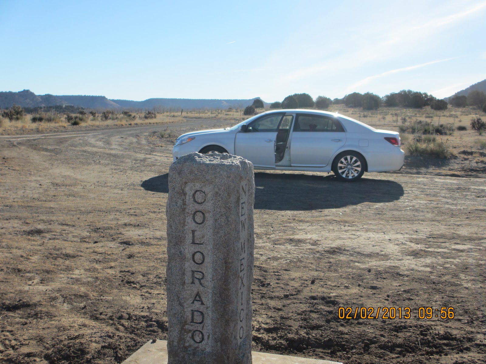
panhandle, including Texas and Cimarron Counties (Please see table for the
(lack of) density stats), the Black Mesa, the city of Kenton, and the tri-state
border of Oklahoma, Colorado, and New Mexico; all before heading home.
It was cool (21 degrees) and crisp as we
headed west towards Boise City, Colorado, and New Mexico! The picture, above, is actually the sun
rising behind us as we drove west from Guymon towards Boise City. The horizon is very flat, with only telephone
lines to give perspective in front of a sunrise that glowed like a burning fire
across the horizon. It was
breathtaking. I sat there for about ten
minutes watching the colors and hues shift around. After a 2nd cup of coffee in Boise
City at “Quick Stop” (there is no McDonald’s, and definitely no Starbucks), we
headed west and north through the prairies.
I stopped at the Black Mesa State
Park and spoke with the Ranger for about 10 minutes. He told me I was only
the 3rd person that had stopped by his lonely office all year! He gave me a map (hand drawn) to the Dinosaur
tracks and the tri-state marker. Both of
these are on private land, so I wouldn’t have found them without his help!
 We followed the trail out of the
State Park, up through Kenton, Oklahoma.
This is a very small town (current population, 18)! It used to be an important town (established
in 1891), during the Santa Fe Trail days.
In those days there was a cattle trail (think “The Chisholm Trail”) that
connected the Santa Fe area and famous Kansas City stockyards. Today, Kenton is famous for it being the only
town in Oklahoma that is on Mountain Time, like Colorado (3 miles north) or New
Mexico (2 miles west).
We followed the trail out of the
State Park, up through Kenton, Oklahoma.
This is a very small town (current population, 18)! It used to be an important town (established
in 1891), during the Santa Fe Trail days.
In those days there was a cattle trail (think “The Chisholm Trail”) that
connected the Santa Fe area and famous Kansas City stockyards. Today, Kenton is famous for it being the only
town in Oklahoma that is on Mountain Time, like Colorado (3 miles north) or New
Mexico (2 miles west).  After driving north for a few
miles, we were on the edge of the beautiful and majestic Black Mesa. This beautiful geologic feature is the result
of a hard layer of volcanic basalt that has resisted erosion, leaving the flat
“table-like” feature. Mesa is the
Spanish word for table. There is a
parking lot (in the middle of nowhere) where you can park while you can hike
(4.2 miles each way) and climb the mesa to the highest point in Oklahoma, at
4,973 feet (almost one mile). As it was
still pretty cold and lonely out there, I decided Loma and I didn’t need an 8
mile hike. Instead, we visited found the
Dinosaur footprints in the creek-bed, and visited the point where the states of
Colorado, New Mexico, and Texas meet.
After driving north for a few
miles, we were on the edge of the beautiful and majestic Black Mesa. This beautiful geologic feature is the result
of a hard layer of volcanic basalt that has resisted erosion, leaving the flat
“table-like” feature. Mesa is the
Spanish word for table. There is a
parking lot (in the middle of nowhere) where you can park while you can hike
(4.2 miles each way) and climb the mesa to the highest point in Oklahoma, at
4,973 feet (almost one mile). As it was
still pretty cold and lonely out there, I decided Loma and I didn’t need an 8
mile hike. Instead, we visited found the
Dinosaur footprints in the creek-bed, and visited the point where the states of
Colorado, New Mexico, and Texas meet.
In the book Mapheads, that Sarah gave me, the story is told that this
tri-state marker, which sits in the middle of a field has been moved five
different times, as more sophisticated mapping techniques have shifted the
“exact location” of the marker. Maybe
they should have put it on wheels! I
should have called my friend Ali, completing her senior year at Colorado School
of Mines, to tell her that Kenton is on Mountain time!
 Having reached Colorado before
10:00 (okay 9:00 MST!), it was time to turn around and head back towards
home. We stopped and played at the
dinosaur footprints for a while. It is
interesting that Loma can fit inside these steps. Somehow I can’t imagine her chasing one of
these monsters around the fields, can you?
Having reached Colorado before
10:00 (okay 9:00 MST!), it was time to turn around and head back towards
home. We stopped and played at the
dinosaur footprints for a while. It is
interesting that Loma can fit inside these steps. Somehow I can’t imagine her chasing one of
these monsters around the fields, can you?

 Loma (and cows): As I
drove up to the tri-state marker, a herd (is herd the right word???) of big
black cows started chasing the car. In
this part of the world, cattle get fed “cubes” of protein from the back of a
car or truck. So when they see a car,
they think; “Food”! Anyway, on my way
back to the highway, I had to drive through all these cows on the road. They moo’d and bawled, and moved off the
road, but only at cow speed, so slowly!
I had the windows down so Loma could look at the cows which were only 3
feet away from the windows. Loma wanted
no part of it! Instead of looking out
the window, she was laying on the floor in the backseat with a look on her face
that said: “Get
me out of here”!
Loma (and cows): As I
drove up to the tri-state marker, a herd (is herd the right word???) of big
black cows started chasing the car. In
this part of the world, cattle get fed “cubes” of protein from the back of a
car or truck. So when they see a car,
they think; “Food”! Anyway, on my way
back to the highway, I had to drive through all these cows on the road. They moo’d and bawled, and moved off the
road, but only at cow speed, so slowly!
I had the windows down so Loma could look at the cows which were only 3
feet away from the windows. Loma wanted
no part of it! Instead of looking out
the window, she was laying on the floor in the backseat with a look on her face
that said: “Get
me out of here”!
We ventured back through Boise
City, and the Oklahoma panhandle, heading east.
As I had never driven through Texhoma (population ~926), a city that is
half in Texas and half in Oklahoma.
Texhoma is the home town of Steve Pugh (one of my groomsmen). So, I swung south into Texas for a short
drive, then by about 11:00, we were heading back to Edmond.
With nothing but flat scenery
around we made pretty good time, leaving the panhandle. The three panhandle counties (Beaver, Texas,
and Cimarron) are some of the largest counties in Oklahoma, at over 1,800 sq.
miles, each (only Osage County, at 2,251 sq. miles, is larger). The roads are long and straight, allowing for
speeds over 80 mph (thankfully I was the only one who noticed)!
 Loma (and the Land Run)
Oklahoma is famous for its Land Run, in which pioneers lining the
Oklahoma-Kansas border rode south, into Oklahoma, to claim land, in 1889. Well, at one point, I saw a memorable outcrop
of rocks on the side of the road; so I stopped, opened my door and stepped out
to get a picture. After I got in the car
and started driving away, I looked in the back seat to see if Loma had woken up
to look out the window. To my surprise
(and horror), she wasn’t in the back of the car! In fact, she wasn’t in the car at all! I looked up into the rear-view mirror, and
there was Loma, about a hundred yards behind me, running for all she was worth
to catch up! She had, apparently,
slipped out of the car when I got out to take the picture, thinking it was an
“environmental break”. I don’t know who
was more surprised and worried as she jumped back in the car and hunkered down
in her bed! I couldn’t stop laughing at
the look of Loma running in the mirror.
She was reenacting the Oklahoma land run; the four legged variety!
Loma (and the Land Run)
Oklahoma is famous for its Land Run, in which pioneers lining the
Oklahoma-Kansas border rode south, into Oklahoma, to claim land, in 1889. Well, at one point, I saw a memorable outcrop
of rocks on the side of the road; so I stopped, opened my door and stepped out
to get a picture. After I got in the car
and started driving away, I looked in the back seat to see if Loma had woken up
to look out the window. To my surprise
(and horror), she wasn’t in the back of the car! In fact, she wasn’t in the car at all! I looked up into the rear-view mirror, and
there was Loma, about a hundred yards behind me, running for all she was worth
to catch up! She had, apparently,
slipped out of the car when I got out to take the picture, thinking it was an
“environmental break”. I don’t know who
was more surprised and worried as she jumped back in the car and hunkered down
in her bed! I couldn’t stop laughing at
the look of Loma running in the mirror.
She was reenacting the Oklahoma land run; the four legged variety!
We
arrived home around 6 PM on Saturday evening.
We covered right as 900 miles, and I added 11 new counties to my
list. So far (I think), I have visited
56 of the 77 counties in Oklahoma. One
group is in the NE corner of the state.
I am hoping that Susan and I get to go canoeing the Arkansas River
around Tahlequah sometime this spring.
The other corner is the far SW part of the state. Maybe I can visit those counties on my way to
see Erin & Hutt in Graham. If you
know me, you know I love to plan new trips!
Happy traveling!
.jpg)